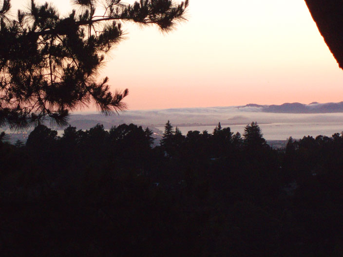
What you've been waiting for...Fog...
-
OliverG
- Old School

- Posts:5326
- Joined:Sat Feb 07, 2004 5:03 pm
- Location:Oakland, CA
- Contact:
As seen from the deck around 8pm Tuesday evening. It's moving somewhat slow and pressure is keeping it low, but I'm hoping to wake up to a lot less visibility than this. Could be a good start for wind through the weekend?
-
Bulldog

- Old School
- Posts:1783
- Joined:Thu Jun 22, 2006 7:23 pm
- Contact:
-
dewey

- Old School
- Posts:1079
- Joined:Mon Apr 05, 2004 8:28 am
- Contact:
-
narly1

- Regular

- Posts:540
- Joined:Tue Mar 07, 2006 7:36 am
- Location:alameda
- Contact:
-
Proparoo
- Regular
- Posts:612
- Joined:Wed Mar 15, 2006 1:59 pm
- Location:Sacramento CA
- Contact:
Weather.com is calling for "High Winds" Friday and Sunday,
They called it right on this past weekend even though it was from the North.
It appears we will have a slight cool down for the weekend and this is usuially a good sign. It's been real hot here in Sacramento...
Cross our fingers... could be the start of the Summer pattern.
They called it right on this past weekend even though it was from the North.
It appears we will have a slight cool down for the weekend and this is usuially a good sign. It's been real hot here in Sacramento...
Cross our fingers... could be the start of the Summer pattern.
Rich "ATOM" Baum
-
Proparoo
- Regular
- Posts:612
- Joined:Wed Mar 15, 2006 1:59 pm
- Location:Sacramento CA
- Contact:
Here is the Sacramento Forecast Discussion, looks real good for Friday
AREA FORECAST DISCUSSION
NATIONAL WEATHER SERVICE SACRAMENTO CA
230 AM PDT WED MAY 9 2007
.DISCUSSION...
THE TROUGH OF LOW PRESSURE THAT WILL CONTINUE TO BE
LOCATED OFF THE PACIFIC NORTHWEST TODAY AND THE RIDGE OF HIGH
PRESSURE OVER CALIFORNIA WILL SLOWLY WEAKEN THE NEXT COUPLE OF
DAYS. MARINE LAYER HAS REDEVELOPED THIS MORNING ALONG THE
COAST AND IN THE BAY AREA AND THAT WILL HELP TO COOL
TEMPERATURES A BIT TODAY. ONSHORE GRADIENT SFO-SAC AT 2.2 MB
THIS MORNING AND SHOULD INCREASE TO AROUND 3.5 MB BY 00Z. THE
STRONGER ONSHORE FLOW COUPLED WITH 850 MB TEMPERATURES COOLING A
DEGREE OR TWO OVER THE REGION SHOULD BRING SOME NOTICEABLE COOLING
FOR MANY AREAS TODAY. A WEAK DISTURBANCE TODAY OVER THE FAR NORTH
LOOKS LIKE IT COULD BRING SOME MORE ISOLATED THUNDERSTORM ACTIVITY
TODAY OVER THE SAME GENERAL AREAS AS YESTERDAY...MAINLY OVER THE
SHASTA-TRINITY FOREST AND POINT NORTHWARD INTO SISKIYOU COUNTY.
GREATER COOLING FOR THE CENTRAL VALLEY IS EXPECTED ON THURSDAY AS
THE MARINE AIR ALONG THE COAST IS EXPECTED TO MAINTAIN A GREATER
PRESENCE AND THE ONSHORE FLOW OVERNIGHT IS EXPECTED TO BE STRONGER
THAN THIS MORNING. THE MARINE LAYER LOOKS TO REMAIN FAIRLY SHALLOW
UNTIL AT LEAST FRIDAY NIGHT WHEN IT LOOKS LIKE IT SHOULD DEEPEN.
TEMPERATURES WILL RETURN TO NEAR SEASONAL NORMALS BY THIS WEEKEND.
GFS IS INDICATING SEVERAL WEAK DISTURBANCES THIS WEEKEND THAT COULD
BRING SOME ISOLATED SHOWER AND THUNDERSTORM ACTIVITY TO THE
MOUNTAINS...PARTICULARLY OVER THE NORTH. SO WE MAY NEED TO ADD A
MENTION OF THAT IN LATER FORECASTS.
Rich "ATOM" Baum
-
dewey
- Old School
- Posts:1079
- Joined:Mon Apr 05, 2004 8:28 am
- Contact:
-
OliverG
- Old School
- Posts:5326
- Joined:Sat Feb 07, 2004 5:03 pm
- Location:Oakland, CA
- Contact:
-
dewey
- Old School
- Posts:1079
- Joined:Mon Apr 05, 2004 8:28 am
- Contact:
-
fearlu

- Resident

- Posts:965
- Joined:Thu Mar 04, 2004 9:24 am
- Contact:
Who is online
Users browsing this forum: No registered users and 4 guests