.this is for the bay
..SMALL CRAFT ADVISORY IN EFFECT FROM WEDNESDAY MORNING THROUGH WEDNESDAY EVENING... .TONIGHT...SW WINDS 10 TO 20 KT WITH OCCASIONAL GUSTS TO 25 KT... EASING TO 5 TO 15 KT OVERNIGHT. .
WED...W WINDS 5 TO 15 KT....BECOMING [glow=red]NW 15 TO 25[/glow] KT BY THE AFTERNOON. A SLIGHT CHANCE OF RAIN. .
WED NIGHT...NW WINDS 15 TO 25 KT...BECOMING SW WINDS 5 TO 10 KT OVERNIGHT. A SLIGHT CHANCE OF RAIN.
.THU...SW WINDS 5 TO 10 KT...BECOMING NW 10 TO 20 KT IN THE AFTERNOON. A SLIGHT CHANCE OF RAIN. .THU NIGHT...W WINDS 10 TO 20 KT...BECOMING SW WINDS 5 TO 10 KT OVERNIGHT. A SLIGHT CHANCE OF RAIN. .
FRI...SW WINDS 5 TO 10 KT...BECOMING NW 10 TO 20 KT
lets hope
himmmm.....
-
charlie

- Old School

- Posts:1254
- Joined:Fri Mar 05, 2004 7:15 am
- Location:alameda calif
- Contact:
charlie
-
Pablito
- Resident

- Posts:697
- Joined:Sun Jul 11, 2004 5:20 pm
- Location:Winters
- Contact:
-
OliverG
- Old School
- Posts:5326
- Joined:Sat Feb 07, 2004 5:03 pm
- Location:Oakland, CA
- Contact:
Looks good!
Btw, this is the source for the NWS forecasts, which are reasonably good. Keep in mind they're meant for the safety of the public, rather than kiters or windsurfers and may be a little conservative as they'd rather overstate conditions than understate them, but I find them to be quite good.
And anytime there's any color-coding for the Bay, it's good.
-
OliverG
- Old School
- Posts:5326
- Joined:Sat Feb 07, 2004 5:03 pm
- Location:Oakland, CA
- Contact:
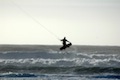
I was amazed he made it back to the launch, I don't recall seeing anyone go out so far and downwind on a reach and actually making it back to the launch. I thought he'd end up in the far cove by Seabreeze or on the Frontage Rd. beach for sure, and I always wince when that happens. #-o I guess the 17m caught a puff and came through for him.... O:)charlie wrote:Pablito
for a man who never kited berkely befor you did very well
heads up.....soner or later berkely will want dues
-
fearlu
- Resident
- Posts:965
- Joined:Thu Mar 04, 2004 9:24 am
- Contact:
-
Pablito
- Resident
- Posts:697
- Joined:Sun Jul 11, 2004 5:20 pm
- Location:Winters
- Contact:
Well, in the end it's always up to Charlie's "Wind God", but I was really, really determined NOT to end up on that beach (or on the freeway, for that matter) with all you Berkeley locals watching.
I did hit a couple of rocks on my way back around the point, though. I'm sure there are many more dues to pay...
I did hit a couple of rocks on my way back around the point, though. I'm sure there are many more dues to pay...
-
charlie
- Old School
- Posts:1254
- Joined:Fri Mar 05, 2004 7:15 am
- Location:alameda calif
- Contact:
its that swim in thing i was talk n about, that happens at berkely
rocks are a new one to me ,i guess you charted new waters
rocks are a new one to me ,i guess you charted new waters
Last edited by charlie on Wed Nov 02, 2005 7:11 am, edited 1 time in total.
charlie
-
charlie
- Old School
- Posts:1254
- Joined:Fri Mar 05, 2004 7:15 am
- Location:alameda calif
- Contact:
and ollies color is gone from the map
231 AM PST WED NOV 2 2005 .TODAY...W WINDS 5 TO 15 KT....BECOMING NW 10 TO 20 KT BY THE AFTERNOON.
A CHANCE OF RAIN. .TONIGHT...NW WINDS 10 TO 20 KT...BECOMING SW WINDS 5 TO 10 KT OVERNIGHT. A SLIGHT CHANCE OF RAIN. .
THU...SW WINDS 5 TO 10 KT...BECOMING NW 10 TO 20 KT IN THE AFTERNOON. A SLIGHT CHANCE OF RAIN. .THU NIGHT...W WINDS 10 TO 20 KT...BECOMING SW WINDS 5 TO 10 KT OVERNIGHT. A SLIGHT CHANCE OF RAIN. .FRI...SW WINDS 5 TO 10 KT...BECOMING NW 10 TO 20 KT DURING THE AFTERNOON AND EVENING. A SLIGHT CHANCE OF RAIN.
.SAT AND SUN...SW WINDS 5 TO 15 KT...BECOMING NW 15 TO 25 KT DURING THE AFTERNOON AND EVENING HOURS.
charlie
Who is online
Users browsing this forum: No registered users and 4 guests